
CALL TO PLAN YOUR TRANSFER020 3951 6136London journey enquiries
Paddington District&Circle
AIRPORTS. STATIONS. YOUR NEXT CHAPTER.

UNDERGROUND STATIONPaddington Taxis & Minicabs.
Your Next Connection.

Make a road connection at Paddington. Check the station details, choose your onward destination and prepare your journey.

01 — THE ARRIVAL IS PART OF THE JOURNEYExplore destinations ↓
Call to plan your journey ↗WhatsApp usCall or WhatsApp to discuss your journey
YOUR JOURNEY STARTS HERE↗

Where are we taking you?

Plan a booking →

Journey planner · no payment or reservation is made.

Airport to doorstepEvery leg, thoughtfully planned
Make room for the journeyTell us your passengers & luggage
A clearer starting pointYour route. Your schedule.
↗
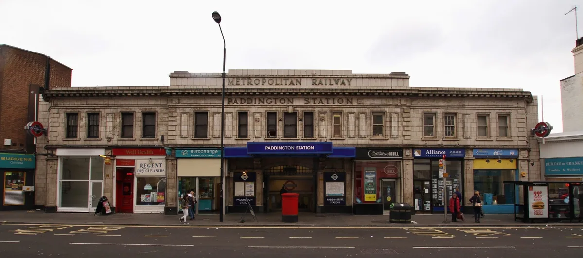
Location photograph · Motacilla / Wikimedia CommonsFile & credit ↗CC BY-SA 4.0 ↗
KNOW THE PLACE. PLAN THE JOURNEY.

Paddington Taxi & Minicab Guide

Local context, transport connections and practical details for your next cab journey.

STATION ADDRESSPaddington Underground Stations, Praed St, London, W2 1HQ
UNDERGROUND LINESBakerloo · Circle · District
FARE ZONE1
Current TfL information ↗
Paddington District&Circle
Praed Street front of London Underground District and Circle lines stationMotacilla / Wikimedia Commons / CC BY-SA 4.0 · Wikimedia Commons · CC BY-SA 4.0

Paddington: Location and Local Orientation

Paddington Underground station is recorded by TfL at Paddington Underground Stations, Praed St, London, W2 1HQ. Use Praed St and postcode W2 1HQ to anchor your taxi or cab enquiry rather than a broad neighbourhood name. Its Underground fare-zone reference is 1; a Tube fare zone does not set the price of a taxi or minicab. TfL also identifies Paddington (Circle / Hammersmith & City) with Circle and Hammersmith & City services separately. Include the line or station site in your collection instructions.

The closest other Underground station positions in this directory are Paddington (Circle / Hammersmith & City) (0.25 km), Lancaster Gate (0.54 km), and Edgware Road (Bakerloo) (0.56 km). Those figures are straight-line distances calculated from TfL coordinates, not walking routes, station interchanges or journey-time estimates.

The published station postcode falls in the Westminster local-authority area (Hyde Park ward). These postcode boundaries are administrative references; use your actual street destination when arranging a minicab.

Named Places Around Paddington

Named green-space landmarks around Paddington include St Mary's Gardens (public park or garden, approximately 0.41 km to the mapped boundary); Kensington Gardens (public park or garden, approximately 0.55 km to the mapped boundary); Hyde Park (public park or garden, approximately 0.57 km to the mapped boundary). These are straight-line distances derived from the TfL station position and Ordnance Survey’s April 2026 mapped site polygons. A boundary can be much closer than a usable entrance: these figures do not describe walking routes, road access or a place for a driver to wait.

If your journey ends at St Mary's Gardens, give its own entrance or street address when booking. A taxi booking for the Underground station identifies a different destination from the surrounding park, grounds or sports site. Confirm visitor arrangements with the site before travelling. Contains Ordnance Survey data © Crown copyright and database right 2026.

Paddington’s Mainline Station and Underground Access

Network Rail’s station map distinguishes the mainline platforms, Elizabeth line and Underground access around the Paddington complex. The map labels Praed Street, Eastbourne Terrace and Paddington Square. A useful cab request states your arriving service and agreed entrance instead of treating every Paddington connection as one map pin.

Tube Connections at Paddington

Paddington is served by Bakerloo line, Circle line, and District line services, so your arrival line matters when you agree a station meeting point. Bakerloo: Edgware Road (Bakerloo) and Warwick Avenue are the neighbouring named stops shown around Paddington in TfL’s route sequences. Circle: Edgware Road (Circle / District / Hammersmith & City) and Bayswater are the neighbouring named stops shown around Paddington in TfL’s route sequences. District: Edgware Road (Circle / District / Hammersmith & City) and Bayswater are the neighbouring named stops shown around Paddington in TfL’s route sequences.

Check current branches, stopping patterns and planned work with TfL before choosing an onward Tube connection or cab.

Luggage, Access and Your Minicab Meeting Point

The station’s captured TfL facilities reference includes lift facilities listed, escalator facilities listed, and a waiting room listed. Check current access with TfL if stairs or the final walk affect your journey: these are dated facilities references, and a facility listing alone does not establish a complete step-free route.

For a minicab at Paddington, give your actual entrance or nearby address, arrival line and luggage count. Agree a permitted road meeting place; the station address and photograph are location references, not waiting instructions.

Airport Taxi Planning from Paddington

For an airport cab from Paddington, start with the station collection address and the airport terminal, rather than only “London airport”. South Kensington is an example of a Piccadilly-line interchange shared with the Circle and District network; use TfL’s planner to compare that rail option on the day. A dispatcher must separately confirm the road journey, price, vehicle and any airport charges.

YOUR PADDINGTON JOURNEY

Local Taxi & Minicab Questions

Where Should I Identify My Paddington Taxi Pick-up?

Use Paddington Underground Stations, Praed St, London, W2 1HQ as the station reference, then agree the precise road meeting point and entrance with the operator. State the Bakerloo, Circle, and District line site to distinguish the separately recorded station locations. Agree the meeting place before travel.

Which Tube Lines and Neighbouring Stops Help Identify Paddington?

The station is listed for Bakerloo, Circle, and District. Bakerloo route context includes Edgware Road (Bakerloo) and Warwick Avenue. Circle route context includes Edgware Road (Circle / District / Hammersmith & City) and Bayswater. District route context includes Edgware Road (Circle / District / Hammersmith & City) and Bayswater. Check current stopping patterns and branch destinations with TfL.

What Should I Check Before a Minicab Connection with Luggage at Paddington?

TfL’s snapshot lists lift facilities listed, escalator facilities listed, and a waiting room listed, but current availability and the full access route still need checking. Tell the operator your passengers, bags and any practical accessibility or child-seat requirements. Ask the dispatcher to confirm vehicle suitability separately from station access.

Is St Mary's Gardens the Same Collection Address As Paddington Station?

No. OS lists St Mary's Gardens in its public park or garden category, with its boundary approximately 0.41 km in a straight line from the TfL station position. That does not identify a visitor entrance or a permitted road meeting point. Specify the station or the site and agree the actual street address.

Sources & photo information

Local information compiled from the sources below, reviewed 28 October 2026. Check the original source for current access, venue and transport changes.

Data provided by Transport for London.

Contains Ordnance Survey data © Crown copyright and database right 2026

Contains Ordnance Survey data © Crown copyright and database right 2025; Contains Royal Mail data © Royal Mail copyright and database right 2025; Contains National Statistics data © Crown copyright and database right 2025

Motacilla / Wikimedia Commons / CC BY-SA 4.0. Praed Street front of London Underground District and Circle lines station. Resized and encoded for web display; photographic content unchanged. Original image and licensing.

BEFORE YOU SET OFF

A few useful
things to know.

Can I get a price and book online?

This is an journey planning preview. You can prepare and copy your journey details, but live fares, availability, payments and bookings are not connected yet.

What details should I have ready?

Your exact pick-up and destination, date, time, passenger count and luggage. For airport collections, include your flight number and terminal when arranging your transfer.

Can I plan a return transfer?

Yes. Choose Return journey in the form and enter your return date. Each leg will need its own confirmed pick-up time before booking.

What about child seats or accessible travel?

Add any requirements to your journey summary. Vehicle suitability, child seats and accessibility arrangements must be confirmed with the operator before you book.

WHEREVER COMES NEXT.

Let’s get you there.

Plan your transfer ↗
YOUR JOURNEY OUTLINE

A good start.

No quote has been issued and no booking has been made. Live pricing and operator contact will be added once confirmed.

Email this journey enquiry ↗

Opens your email app. Review and send the message there; this website does not submit it automatically.

Continue to booking preview →
020 3951 6136Call operatorWhatsApp
FOLLOW THE JOURNEY

Profiles coming soon.

Our operator’s Facebook, Instagram, TikTok and Twitter / X profile links have not been supplied yet. These preview icons will connect to the real profiles once configured.